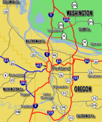
Ultimate Interstates:Pacific Northwest


Oregon and Washington would see a number of interstate improvements. The maps show these various improvements. Solid Blue Lines indicate new free and purple indicates toll interstate routes. Dotted lines show additional Proposed routes or alternative routes. Red lines show existing Interstate highways.
Corridor 1
Ultimate Interstate 1 is an interstate highway corridor that travels up the California Coastline from Los Angeles to San Francisco. This route could also be extended northward along the Oregon and Washington coastline to Olympia, WA.
The route would largely replace US 101 throughout most of the state. However through the bay area it would replace I-880 along the east bay and cross using the San Rafael bridge (I-580) which is where it would route back over to back to the US-101 alignment northward. Main Article
Corridor 11
Originating from Gila Bend, Arizona I-11 travels north into Nevada crossing the new Colorado River Bridge near the Hoover Dam. This interstate would replace existing US-93 and I-515 south of Las Vegas. North of Las Vegas the route will generally follow US-95 northward throughout the state north through Fallon. I-11 would be cosigned with I-80 from Fallon Junction to Winnemucca before continuing north along US-95 into Oregon. Eventually the route continues north toward Boise and Lewiston eventually ending in Spokane.
I-84 Extension
From its existing terminus in Utah, this interstate would generally follow existing US-50/6 route to Ely. From there the interstate would continue west along one of two possible routes. From Ely the northern route follows along US-50 to Fallon and then ends in Fernley terminating at I-80. The southern route would generally follow US-6 toward Tonopah and Bishop connecting to I-11 and ending at I-9 where at some point it could be extended westward into California as a second interstate route to the California Central valley and Bay Area region.